
PHOTOGRAPH OF OURAY, COLORADO
Image: 7 ¼” x 4 ¾”. Mount: 8” x 5”. An albumen silver print: “#1612 of Ouray from the North”. Geo. E. Mellen’s Colorado Views is imprinted on the verso, along with C.H. Clark, Publisher..... More
Image: 7 ¼” x 4 ¾”. Mount: 8” x 5”. An albumen silver print: “#1612 of Ouray from the North”. Geo. E. Mellen’s Colorado Views is imprinted on the verso, along with C.H. Clark, Publisher..... More

Mount: 4 ¼” x 7”. Image: 3 ½” x 6 ¼”. Undated and unmarked stereoview, circa 1880, of the town of Idaho Springs, Colorado. Identified with a holographic notation on the verso. Founded in 1859..... More

Partial handwritten land deed for the purchase of a tract of land for $100 and a second-hand wagon. The property was originally acquired by John M. Cox and Robert M. Kidder under the Homestead Act..... More

Sioux Falls: Will A. Beach, 1902. Interesting locally produced map by E. Frank Peterson of Vermillion, South Dakota, promoting the “Famous Artesian Belt” of eastern South Dakota. The counties and reservations are outlined in red..... More

Denver: The Clason Map Co., 1916. Includes a geographical index of towns and a table of railroad distances. The population of the state at the time was 98,726 and Las Vegas was little more than..... More

Boston, Massachusetts: March 18, 1865. Engraved and printed in black on thin blue stock (7 ¾” x 6 ¾”) with a green stamp, this is certificate number 143, signed. Faded revenue stamp pasted on the..... More

[Colorado Springs], Colorado: August 18, 1885. Engraved and printed in purple and green on thin cream stock (14 ¾” x 15 ½”), this is bond number 4, signed. $500, 10 percent bond secured by a...... More

Del Norte, Colorado: October 28, 1875. Engraved and printed in black on thin cream stock (11” by 8”), this certificate No. 62 is for 100 shares of capital stock for $100 each. The certificate is..... More

Des Moines, Iowa: The Kenyon Company, 1918. A color map showing all the railroads, cities, towns, post offices, rivers, telegraph stations, money order post offices, and chief auto roads. The population of the state at..... More

New York: G.W. and C.B. Colton, 1886. Hand-colored, pre-statehood map published only three years before the Dakota Territory was split into North and South Dakota. Depicts the various counties, railroads, and townships, with relief indicated..... More

A collection of letters written by pioneering Oklahoma attorneys C.O. Blake and Ernest Blake to their parents between 1884 and 1906. In a letter from Indianapolis dated January 12, 1884, C.O. Blake (1860–1924) laments..... More

Highmore, South Dakota: E.J. Quirk Land Company, 1908. Promotional information is printed on the verso of the map. “South Dakota, a wonderful farming country; great agriculture, live stock; great in mineral wealth and natural resources.”..... More

Winner, South Dakota: Tripp County Abstract Co., circa 1940. Scarce cadastral map of Tripp County, located in south central South Dakota, bordering Nebraska, with the meandering White River serving as its northern boundary. Land ownership..... More

San Francisco, Chicago, New York: Rand McNally & Company, 1925. Highly detailed three-color map of Montana, delineating the county borders, showing relief by hachure, and indicating the locations of thirteen railroads. Another map, printed on..... More

Chicago and New York: Rand, McNally & Co., 1908. Uncommon folding map of the Arizona Territory, published four years before statehood. In addition to locating all cities, towns, post offices, railroad stations, villages, counties, islands..... More

Chicago: Rand McNally & Company, 1907. Highly detailed map of Colorado, delineating its counties by color and indicating the locations of 28 railroads. A key along the left margin supplies the location and population of..... More

San Francisco: Pacific Highway Association of California, circa 1930. Highly detailed folding map with large cartographic renderings of the highway system in California, Oregon, and Washington, along with several insets, including street diagrams and traffic..... More
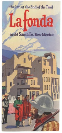
A collection of travel brochures and a map dating from the 1950s for travel in Santa Fe, New Mexico. The materials were likely gathered as part of a trip to the southwestern city for the..... More

Highmore, South Dakota: Keiser Land Company, 1910. Printed by Will A. Beach in Sioux Falls, using the E. Frank Peterson map of South Dakota to promote settlement in Stanley, Sully, Hughes, Hyde, and Hand Counties..... More

Denver: The Denver Litho Co., July 25, 1899. Engraved and printed in black, green, and red on thin cream stock (14 ¾” x 15 ½”), this is bond number 54, unsigned. $500, six percent bond..... More

Denver: W.H. Jackson & Co. Photo, [1896]. Hand color-tinted photograph, image: 9” x 3 ½”, mount: 15” x 9 ¼”. Although Leadville was one of the largest boomtowns in Colorado, the mines were in..... More

Four quit-claim deeds dating from the 1880s involving women in property transfers at a time when women’s property rights were severely restricted nationwide. A deed dated September 17, 1885, recorded the purchase of a lot..... More